


Dave Catts
Current Gallery: islands ( piece)
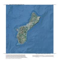
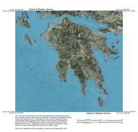
Maps and map artwork from an assortment of tropical and mid-latitude locations. Some with text and overlays, some just the artwork. All birds-eye views of familiar places, cruising grounds, and ports-of-call to visit and recreate. The map titles are from a central physiographic feature and contain over-edge. All images are vertical views (planimetric) of 3D environmental models, and the image corners are specific geographic coordinates (georectified), unless otherwise stated. These images are 10,000-pixels in the longest dimension; so they can accomodate the "Massive" print size at Imagekind.
Maps and map artwork from an assortment of tropical and mid-latitude locations. Some with text and overlays, some just the artwork. All birds-eye views of familiar places, cruising grounds, and ports-of-call to visit and recreate. The map titles are from a central physiographic feature and contain over-edge. All images are vertical views (planimetric) of 3D environmental models, and the image corners are specific geographic coordinates (georectified), unless otherwise stated. These images are 10,000-pixels in the longest dimension; so they can accomodate the "Massive" print size at Imagekind.
Gallery-quality prints · Independent artists · Décor to adore


from $ 63

from $ 63
from $ 63

from $ 63

from $ 63

from $ 63
from $ 63

from $ 63

from $ 63

from $ 63

from $ 63

from $ 63

from $ 63

from $ 63

from $ 63

from $ 63

from $ 63

from $ 63